| Author | L. | |
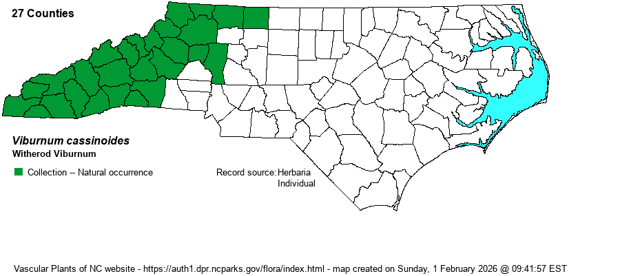
| Distribution | Throughout the Mountains, and sparingly into the Piedmont foothills east to Stokes and Iredell counties. [Note that the BONAP county range map includes V. nudum merged into V. cassinoides as a single species.]
This is a Northern species, ranging from southern Canada south essentially though the mountains to northern GA and AL.
| |
| Abundance | This species is fairly common to common in the higher elevations, and infrequent at low elevations, including the Piedmont foothills. | |
| Habitat | This is a species of a variety of cool, usually moist forests. It is most often found in moist forests and bogs, but it is also found in upland forests (often where rocky) and outcrops. | |
| Phenology | Blooms from late May into June; fruits from August to October. | |
| Identification | This is a medium-sized deciduous shrub with opposite leaves, often growing to 6-8 feet tall. It has ovate to nearly elliptic leaves, usually with a narrowed tip, to an average of 3 inches long. Unlike most viburnum species, the leaves have only slightly visible serrations. Also, the leaves show a very strong, indented, and whitish mid-vein. This shrub might be tricky to identify without reproductive parts; fortunately, during most of the growing season the large slightly rounded cluster of small white flowers at the branch tips, or the clusters of blue-black fruit with a whitish bloom, are usually easily seen. | |
| Taxonomic Comments | This species is usually considered a species separate from V. nudum, which grows mainly in the Piedmont and Coastal Plain. However, some references do merge them; when that is done, this taxon in some references becomes the nominate variety – V. cassinoides var. cassinoides, or conversely in others – V. nudum var. cassinoides.
| |
| Other Common Name(s) | Northern Wild-raisin, With-rod | |
| State Rank | S4 | |
| Global Rank | G5 | |
| State Status | | |
| US Status | | |
| USACE-agcp | | |
| USACE-emp | | |

