Vascular Plants of North Carolina
Account for Southern Roughleaf Goldenrod - Solidago salicina   Elliott
Members of Asteraceae:
Members of Solidago with account distribution info or public map:
Google Images
Section 6 » Family Asteraceae
Show/Hide Synonym
AuthorElliott
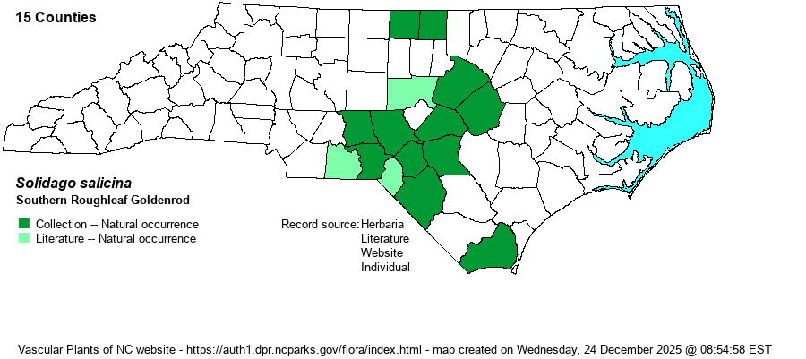
DistributionMainly the Sandhills; also adjacent counties -- mainly in the southern Coastal Plain -- in seepage habitats; Brunswick County in "margin of bay"; Caswell and Person counties (in the northeastern Piedmont) in seepages at bases of slopes.

Mostly the Coastal Plain, southeastern VA to northwestern FL, TX, OK, AR.
AbundanceUncommon to frequent in the Sandhills; rare to locally uncommon in nearby regions, but very rare as far north as the VA border and to Brunswick County. Though this is a Watch List species, it perhaps is numerous enough not to need such a status.
HabitatWet sphagnous or mucky soils of blackwater streamheads and ecotones, wet margin of bay (Brunswick Co.), seepages at bases of forested slopes (Caswell and Person counties).
PhenologyFlowering and fruiting September-October.
IdentificationSouthern Roughleaf Goldenrod is robust, 3-6 feet tall, from a rosette of large basal and lower stem leaves (to 1 foot long and 2-3 inches wide) that vary from toothed to smooth-ish. Stem leaves gradually become smaller upward. All leaves are roughly textured on the upper surface, like sandpaper. The inflorescence is broad, with lax branches that curve outward. Northern Roughleaf Goldenrod (S. patula) is similar but its leaves are much wider (to 4 inches) and coarsely toothed. Note also its different range, essentially just the mountains. Though most often found in the state in the Sandhills, it may require looking in quite a few streamhead pocosins before you stumble onto this quite imposing plant.
Taxonomic CommentsSome authors include this as a variety or subspecies of S. patula, i.e., var. strictula.

Other Common Name(s)Southern Roundleaf Goldenrod, Streamhead Roughleaf Goldenrod
State RankS2? [S2S3]
Global RankG5T5
State StatusW1
US Status
USACE-agcp
USACE-emp
County Map - click on a county to view source of record.
Photo Gallery
photographercommentsphoto_linkcountyobsType
B.A. SorrieMoore County, same data. Midstem leaves. MoorePhoto_natural
B.A. SorrieMoore County, 2017, broad wet powerline between Pinewild Golf and Pine Valley development. MoorePhoto_natural
Select a source
AllHerbaria
Individual
Literature
Website
Select an occurrence type
AllCollection_naturalLiterature_naturalPhoto_naturalSight_natural